www.CADUTILS.com - more CAD for you!
Tags
ZWCAD Utilities (8)
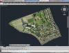
With CAD-Earth© you easily import/export images, objects and terrain meshes between Google Earth™ and major CAD programs
Now you can import georeferenced images and terrain meshes exactly as you see them in them in Google Earth. If you have placemarks, polygons, image overlays or routes in Google Earth they will appear in the image imported to your CAD application.
You will have the ability to preview position of selected drawing entities in a map when selecting a coordinate system to georeference a drawing. Drawing entities can be moved, scaled or rotated in the map until they match the site.
The CAD-Earth Demo Version has a limit of 500 points when importing a terrain mesh from Google Earth™. Only 10 objects can be imported to or exported to Google Earth™. Also, all images imported to or exported to Google Earth™ have ‘CAD-Earth Demo Version’ text watermark lines. The CAD-Earth Registered Version can process any number of points and objects and the images don’t have text watermark lines.
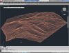
With CAD-Earth© you easily import/export images, objects and terrain meshes between Google Earth™ and major CAD programs
Now you can import georeferenced images and terrain meshes exactly as you see them in them in Google Earth. If you have placemarks, polygons, image overlays or routes in Google Earth they will appear in the image imported to your CAD application.
You will have the ability to create a terrain configuration mesh and get contour lines, profiles and sections.
The CAD-Earth Demo Version has a limit of 500 points when importing a terrain mesh from Google Earth™. Only 10 objects can be imported to or exported to Google Earth™. Also, all images imported to or exported to Google Earth™ have ‘CAD-Earth Demo Version’ text watermark lines. The CAD-Earth Registered Version can process any number of points and objects and the images don’t have text watermark lines.
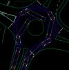
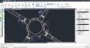
Free AutoCAD and ZWCAD+ tool! Now with Vehicle Turning Simulation (Swept path analysis)
CadTools (ToolBox) is a software developed for Civil Engineers using AutoCAD or ZWCAD.
With CadTools you can create your own surface models based on objects in the drawing or import triangles from DWG (other civil software). You can create profiles and cross-sections of multiple surfaces, calculate volumes and plot contours.
Vehicle turning software simulates vehicle turning at low speed and determines vehicle tire tracking and swept paths. Its useful in the design of road intersections, parking lots and other vehicular facilities.
10 default types of vehicles are supported. Every vehicletype has its own figuration ruled by a combination of segments, the first segment is the truck, the second is either a trailer or a tow bar and so on. You can easily create your own vehicles by copying a existing vehicle and change parameters. You can use up to 4 segments including the truck, that would give you a Triple trailer and we think that would cover most of the common situations.
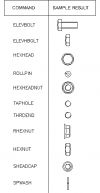
This is great LISP utility - not just a library of profiles but a real application to use inside AutoCAD or others "like AutoCAD" systems. It has a graphical user interface with button selections to get what you need whether it is an end view, top or side view, or a 3D solid. All the dimensions are there including the small radii edges. Once you have made your selection you are given either a standard ACAD solid (not and ARX entity) or a simple 2D drawing. The end views are closed polylines which you can extrude, if needed.
Application helps cost calculations by prepare data for bill of quantities, areal, linear and quantity occurrence.
Functions:
- Area measurement
- Line measurement
- Objects description
- Find
- Select
- Sum of length
- Mdist
- Report
Application is a set of functions which supports the work with ZWCAD, by automation of used commands.
The application is a next generation version of the TOOLS.
It works with version ZWCAD Classic.
Functions:
- Save file with backup
- Inserts point with name and number
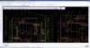
Application is dedicated for road industry.
Using the application the user can create elements of the road, design traffic organization and analyze the path of vehicles.
Application elements:
- Vertical signs
- Horizontal marks
Note: Online eshop links lead to the online stores managed by the relevant producer.
CAD System
Category
