www.CADUTILS.com - more CAD for you!                     

CAD-Earth© Basic

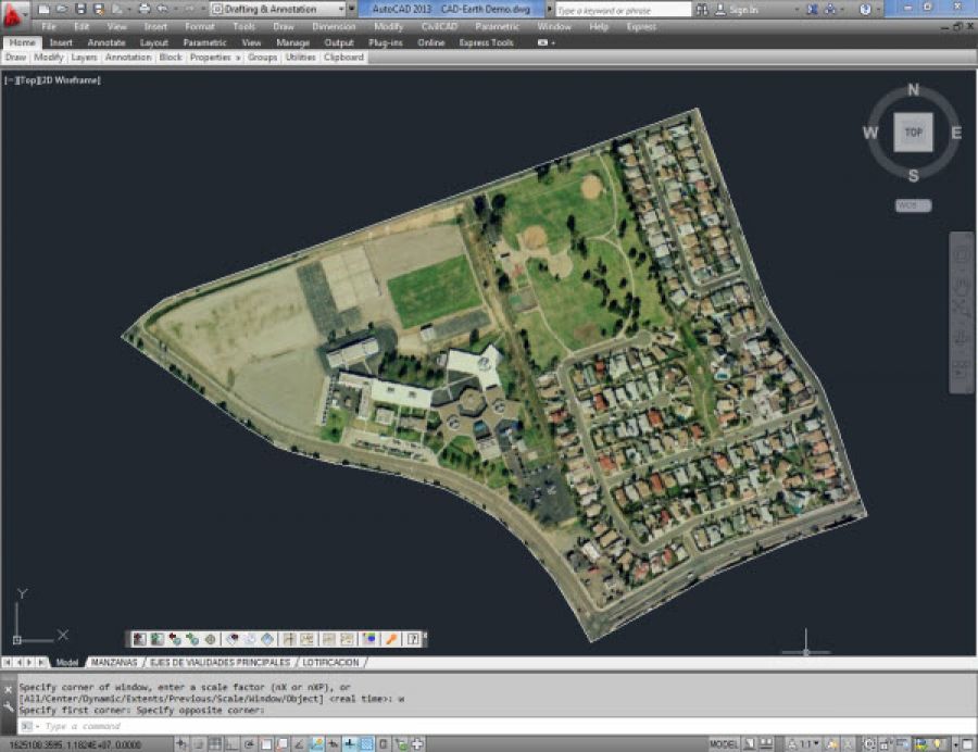
With CAD-Earth© you easily import/export images, objects and terrain meshes between Google Earth™ and major CAD programs

Now you can import georeferenced images and terrain meshes exactly as you see them in them in Google Earth. If you have placemarks, polygons, image overlays or routes in Google Earth they will appear in the image imported to your CAD application.

You will have the ability to preview position of selected drawing entities in a map when selecting a coordinate system to georeference a drawing. Drawing entities can be moved, scaled or rotated in the map until they match the site.

The CAD-Earth Demo Version has a limit of 500 points when importing a terrain mesh from Google Earth™. Only 10 objects can be imported to or exported to Google Earth™. Also, all images imported to or exported to Google Earth™ have ‘CAD-Earth Demo Version’ text watermark lines. The CAD-Earth Registered Version can process any number of points and objects and the images don’t have text watermark lines.

Last modified on Wednesday, 27 January 2016 09:51

Additional Info

  • Features:


    Import georeferenced images and terrain meshes

      • Now you can import georeferenced images and terrain meshes exactly as you see them in them in Google Earth. If you have placemarks, polygons, image overlays or routes in Google Earth they will appear in the image imported to your CAD application.

    No need to georeference your drawing twice

      • If an AutoCAD drawing is already georeferenced you will not have to georeference it again using CAD-Earth commands.

    Mesh creation has been simplified

      • You will no longer have to specify the grid origin point and distance between rows and columns to create a mesh. Now you just have to specify the mesh resolution (normal, medium, high or highest) and optionally the grid rotation when importing terrain meshes from Google Earth.

    Preview position of selected drawing entities in a map

      • Ability to preview position of selected drawing entities in a map when selecting a coordinate system to georeference a drawing. Drawing entities can be moved, scaled or rotated in the map until they match the site.

    Process images up to 10x faster

      • Process images up to 10x faster from different providers (Google, Bing, Yahoo, Ovi) in satellite, map or hybrid image mode in normal, medium, high or highest resolution.

    Map Control for drawing entities

      • New map control where you can preview drawing entities in the real world. You can move, scale and rotate reference entities in real time until they match the exact location.

    Commands to georeference a drawing

      • Avoid misplaced images or objects using new commands to georeference a drawing by locating entities in a map or selecting two points and typing their latitude/longitude coordinates.

    Optimized “import terrain mesh” command

      • The command to import terrain mesh from Google Earth has been greatly optimized for speed and performance.

    Insert georeferenced images

      • If you have image files with the corresponding world file containing spatial data information you can accurately place them in the drawing automatically applying XY scale and translation transformations.

    Export CAD screenshots to Google Earth™

    • Users can export CAD drawings to Google Earth™ as image overlays. Those image captures can be in full color, grayscale or B&W, and are compatible as major image formats (BMP, JPEG, TIFF, PNG, GIF). Background color can be completely transparent or customized to your desired color. Screenshots can be also taken in sections to increase the quality of the final image resolution.

    Commands of CAD-Earth Basic

    • Georeference drawing commands
    • Grab map/image
    • Import image from Google Earth™
    • Import objects from Google Earth™
    • Export CAD screenshot to Google Earth™
    • Export CAD Objects to Google Earth™
  • Publisher: CAD-Earth ©
  • Operating Systems: Windows XP, Vista, 7 and 8
  • CAD Requirements: AutoCAD 207-2016, ZWCAD+ 2014-2015 Pro, BricsCAD V14-V16 Pro and Platinum
  • Other Requirements:
    Google Earth™ Free or Pro version 5 or newer, and also the Google Earth™ Plug-in must be installed in your web browser.
  • License types: Trial/Commercial
  • Price: $ 129

Media

CAD-Earth©

Note: Online eshop links lead to the online stores managed by the relevant producer.

Go to top