www.CADUTILS.com - more CAD for you!
Tags
Landscape (3)
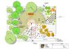
gCADPlus is an affordable easy-to-use CAD tool for professional landscapers. Use AutoCAD commands in a familiar environment to quickly create plans from templates by dragging and dropping symbols or entire designs into place. Cut drafting time and experience the power of automated landscape CAD software. Choose from hundreds of professional symbols or create your own. Re-use previous design work in new jobs. Simplify plant selection by attaching plant database lists and filter those lists to find the correct species for a particular purpose. Automate the creation of plant schedules, ground cover spacing and extract quantities for costing. Store extra data with any entity..
pmxExportKML is a plug-in for Autodesk® AutoCAD® that exports AutoCAD and FDO (Feature Class Objects) objects to a KML version 2.2 file.
The KML file can be opened and viewed in Google Earth or any other application with KML support.
This application is compatible with the following versions of Map 3D or Civil 3D: 2013, 2014, 2015, 2016 and 2017.
RTOPO - CAD for topography Featured
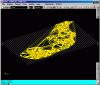
RTOPO - CAD for Topography, editing 3D points, triangulation, isolines, sections.
Together with RTOPO, is distributed the RCAD CAD system. It provides OpenGL real-time orbit, pan, zoom, shading, lighting and motion path animation. RCAD is similar with other popular CAD systems and can load and save DXF files. It has entries in the command text area, graphics area, menus and toolbars. It has commands for drawing and modification. RCAD can also run scripts and can be called from other programs.
Note: Online eshop links lead to the online stores managed by the relevant producer.
CAD System
Category
