www.CADUTILS.com - more CAD for you!
Tags
BricsCAD Utilities (12)
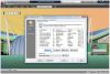
Free BricsCAD tool! for Vehicle Turning Simulation (Swept path analysis)
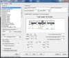
10 default types of vehicles are supported. Every vehicletype has its own figuration ruled by a combination of segments, the first segment is the truck, the second is either a trailer or a tow bar and so on. You can easily create your own vehicles by copying a existing vehicle and change parameters. You can use up to 4 segments including the truck, that would give you a Triple trailer and we think that would cover most of the common situations.
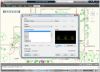
With CAD-Earth© you easily import/export images, objects and terrain meshes between Google Earth™ and major CAD programs
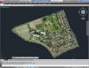
Now you can import georeferenced images and terrain meshes exactly as you see them in them in Google Earth. If you have placemarks, polygons, image overlays or routes in Google Earth they will appear in the image imported to your CAD application.
You will have the ability to preview position of selected drawing entities in a map when selecting a coordinate system to georeference a drawing. Drawing entities can be moved, scaled or rotated in the map until they match the site.
The CAD-Earth Demo Version has a limit of 500 points when importing a terrain mesh from Google Earth™. Only 10 objects can be imported to or exported to Google Earth™. Also, all images imported to or exported to Google Earth™ have ‘CAD-Earth Demo Version’ text watermark lines. The CAD-Earth Registered Version can process any number of points and objects and the images don’t have text watermark lines.
With CAD-Earth© you easily import/export images, objects and terrain meshes between Google Earth™ and major CAD programs
Now you can import georeferenced images and terrain meshes exactly as you see them in them in Google Earth. If you have placemarks, polygons, image overlays or routes in Google Earth they will appear in the image imported to your CAD application.
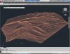
You will have the ability to create a terrain configuration mesh and get contour lines, profiles and sections.
The CAD-Earth Demo Version has a limit of 500 points when importing a terrain mesh from Google Earth™. Only 10 objects can be imported to or exported to Google Earth™. Also, all images imported to or exported to Google Earth™ have ‘CAD-Earth Demo Version’ text watermark lines. The CAD-Earth Registered Version can process any number of points and objects and the images don’t have text watermark lines.
GlobalCAD Architecture Featured
Expert software for architecture and land planning with 2D/3D design libraries, creative content, scheduling tools, and more.
GlobalCAD Architecture is the integrated architectural and land planning add-on solution for AutoCAD, AutoCAD Architecture and BricsCAD.
Utilize unique presentation tools for the creation of stunning hatch patterns and complex linetypes, generated quickly and easily from existing drawing objects.
Create comprehensive schedules and bill of materials from block attribute data at the click of a button! Query drawings for quantities and export data to a variety of file formats including Microsoft Excel and Access.
Create accurate and intelligent site surveys and stunning 3D terrain models with a single mouse click! Using advanced algorithms, 3D models can be produced covering vast areas, both as polyface meshes or solids (including volumetric data).
GlobalCAD Hatch Manager Featured
Create custom hatch patterns based on existing drawing objects. Includes hundreds of pre-drawn designs.
GlobalCAD Hatch Manager provides the solution to all your hatch creation and management needs. You can build entire libraries from scratch, add existing PAT files in seconds or create your own unique patterns from existing drawing objects.
The software also links directly into the AutoCAD / BricsCAD Boundary Hatch (Bhatch) dialog, ensuring all your patterns remain fully featured with essential options such as associative, non-associative, edit boundary and pattern re-scaling.
GlobalCAD Organizer Featured
Authoring tools help you create and manage content libraries including symbols, linetypes and hatch patterns.
GlobalCAD Organizer gives you the tools to create and manage drawing objects like never before! Its unique object-authoring suite includes Block Manager, Hatch Manager, Linetype Wizard and Attribute Wizard. Now you can instantly publish intelligent block libraries, stunning hatch patterns and complex linetypes from existing drawing content.
The software is avaiable for AutoCAD and BricsCAD as well.
GlobalCAD Terrain Featured
Easily create accurate and intelligent site surveys and stunning 3D terrain models in seconds!
The essential tools in GlobalCAD Terrain make it easy to create accurate and intelligent site surveys and stunning 3D terrain models with a single mouse click!.
Working with site survey data forms a critical component of any project. Information can be presented as anything from 2D markers to points in 3D space or contours. GlobalCAD Terrain gives you the tools to generate 'intelligent' surveys, either by converting an existing drawing or starting from scratch. Move any intelligent survey point marker and its associated XYZ value automatically updates to suit the new location!
Furthermore, you can generate 3D surface terrain models covering vast areas with a single mouse click. The terrain is developed by connecting the given survey points and forming triangles to create a surface model. Using advanced algorithms, GlobalCAD Terrain can produce these models as polyface meshes or solids (including volumetric data).
The software is avaiable for AutoCAD and BricsCAD as well.
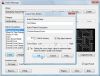
Kordil AcadTRK is a package that contains several LISP utilities useful for menu and mapping tools for AutoCAD above version 12.0. The package also contains CAD tools which supports for CAD programs supporting AutoLISP Languages (such as BrisCAD). The source codes of the utilities in the package are fully customizable and editable, and the package consisting of several programs are easily accessible through a pull-down and icon menus. Those who work on the construction or land surveying and also wish some useful enhancements for AutoCAD may give this package a try! The package works with AutoCAD version 12.0 and above. The package is equipped with an installation wizard and also with an installation instruction.
Kordil AcadTRK package is free of charge. However, it is expected to fill out the form before downloading.
Use pdf2bricscad to transform vector PDF files into editable CAD drawings and save hours of redraw time. Within moments of selecting an appropriate PDF file, an accurate and editable drawing will open within BricsCAD.
pdf2bricscad is ideal for converting computer-generated CAD drawings, floor-plans, network diagrams and organization charts. It extracts editable CAD entities, objects and text from any computer-generated PDF file while images from scanned PDF files are placed on a non-editable tracing layer. PDFin is not designed to operate on scanned drawings (raster PDF).
Note: Online eshop links lead to the online stores managed by the relevant producer.
CAD System
Category
