www.CADUTILS.com - more CAD for you!
Tags
BricsCAD Utilities (12)
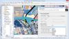
Spatial Manager™ for BricsCAD is a powerful BricsCAD plug-in designed for BricsCAD users who need to import, export and manage spatial data in a simple, fast and inexpensive way, which includes many possibilities not seen so far in BricsCAD. It comes in a lightweight application that runs inside BricsCAD and allows the user to import and export geospatial data between BricsCAD drawings and geospatial files, data servers or data stores.
It enables:
- Import into BricsCAD from Google Earth (KML or KMZ), OpenStreetMap (OSM or PBF), Shapefiles (SHP), Geography Markup Language (GML), GPS, Points (many formats), Excel, Access, ESRI ArcInfo, MapInfo, PostGIS, SQL Server, SQLite, and many more geospatial sources
- Export from BricsCAD to Google Earth (KML or KMZ), Shapefiles (SHP), Points (many formats), MapInfo, PostGIS, SQL Server, SQLite, and many more geospatial targets
- Transformation of coordinates optional
- Manage alphanumeric data tables as BricsCAD Extended Entity Data (EED). Viewer included
- Save Tasks to replay the import processes so many times as desired
Spatial Manager™ for BricsCAD Editions: Basic, Standard, Professional
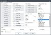
This is great LISP utility - not just a library of profiles but a real application to use inside AutoCAD or others "like AutoCAD" systems. It has a graphical user interface with button selections to get what you need whether it is an end view, top or side view, or a 3D solid. All the dimensions are there including the small radii edges. Once you have made your selection you are given either a standard ACAD solid (not and ARX entity) or a simple 2D drawing. The end views are closed polylines which you can extrude, if needed.
Note: Online eshop links lead to the online stores managed by the relevant producer.
CAD System
Category
