www.CADUTILS.com - more CAD for you!
Tags
GIS (9)
3DINTERSECTION for AutoCAD Featured
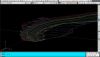
An add-on for AUTOCAD, which determines the 3D intersection curves between 2 sets consisting of 3DFACE, 3DSOLID or 3DMESH entities. The outcome is represented by 3DPOLY entities.
Developed section for AutoCAD Featured

An add-on for AUTOCAD, which determines the developed (unfolded) section of one set of 3DSOLID, 3DMESH or 3DFACE entities and vertical plans passing through a 2D POLYLINE which may contain arcs, in XOY plane.

Kordil AcadTRK is a package that contains several LISP utilities useful for menu and mapping tools for AutoCAD above version 12.0. The package also contains CAD tools which supports for CAD programs supporting AutoLISP Languages (such as BrisCAD). The source codes of the utilities in the package are fully customizable and editable, and the package consisting of several programs are easily accessible through a pull-down and icon menus. Those who work on the construction or land surveying and also wish some useful enhancements for AutoCAD may give this package a try! The package works with AutoCAD version 12.0 and above. The package is equipped with an installation wizard and also with an installation instruction.
Kordil AcadTRK package is free of charge. However, it is expected to fill out the form before downloading.
pmxExportKML is a plug-in for Autodesk® AutoCAD® that exports AutoCAD and FDO (Feature Class Objects) objects to a KML version 2.2 file.
The KML file can be opened and viewed in Google Earth or any other application with KML support.
This application is compatible with the following versions of Map 3D or Civil 3D: 2013, 2014, 2015, 2016 and 2017.
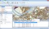
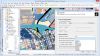
Spatial Manager Desktop™ is a desktop application designed to manage spatial data in a simple, fast and inexpensive way.
It enables: read and write spatial data using a wide range of file formats and spatial servers, Transform geometries between CRSs, Easily create and print maps, Use Tasks to automate any import and export process, Interface simple, intuitive and productive, Lightweight, easy and powerful
Spatial Manager Desktop™ will calculate geometric transformations of the features in line with the import or export processes, which will depend on the chosen Coordinate Reference System (CRS) for the source and target data.
Spatial Manager Desktop™ incorporates the UDS technology to easily connect with spatial database servers, or data stores, and also as the way the user can define the path to a particular spatial data file, including their own connection parameters.
Spatial Manager Desktop™ tasks are the way the user can save any import or export process and its parameters in order to run repetitive processes for import or export data tables.
Spatial Manager Desktop Editions: Basic, Standard, Professional
Spatial Manager™ for AutoCAD is a powerful AutoCAD plug-in designed for AutoCAD users who need to import, export and manage spatial data in a simple, fast and inexpensive way, which includes many possibilities not seen so far in AutoCAD. It comes in a lightweight application that runs inside AutoCAD and allows the user to import and export geospatial data between AutoCAD drawings and geospatial files, data servers or data stores.
It enables:
- Import into AutoCAD from Google Earth (KML or KMZ), OpenStreetMap (OSM or PBF), Shapefiles (SHP), Geography Markup Language (GML), GPS, Points (many formats), Excel, Access, ESRI ArcInfo, MapInfo, PostGIS, SQL Server, SQLite, and many more geospatial sources
- Export from AutoCAD to Google Earth (KML or KMZ), Shapefiles (SHP), Points (many formats), MapInfo, PostGIS, SQL Server, SQLite, and many more geospatial targets
- Transformation of coordinates optional
- Manage alphanumeric data tables as AutoCAD XDATA. Viewer included
- Save Tasks to replay the import processes so many times as desired
- Not only works in basic AutoCAD: also in AutoCAD Map 3D, AutoCAD Civil 3D, AutoCAD Architecture, etc.
Spatial Manager™ for AutoCAD Editions: Basic, Standard, Professional
Spatial Manager™ for BricsCAD is a powerful BricsCAD plug-in designed for BricsCAD users who need to import, export and manage spatial data in a simple, fast and inexpensive way, which includes many possibilities not seen so far in BricsCAD. It comes in a lightweight application that runs inside BricsCAD and allows the user to import and export geospatial data between BricsCAD drawings and geospatial files, data servers or data stores.
It enables:
- Import into BricsCAD from Google Earth (KML or KMZ), OpenStreetMap (OSM or PBF), Shapefiles (SHP), Geography Markup Language (GML), GPS, Points (many formats), Excel, Access, ESRI ArcInfo, MapInfo, PostGIS, SQL Server, SQLite, and many more geospatial sources
- Export from BricsCAD to Google Earth (KML or KMZ), Shapefiles (SHP), Points (many formats), MapInfo, PostGIS, SQL Server, SQLite, and many more geospatial targets
- Transformation of coordinates optional
- Manage alphanumeric data tables as BricsCAD Extended Entity Data (EED). Viewer included
- Save Tasks to replay the import processes so many times as desired
Spatial Manager™ for BricsCAD Editions: Basic, Standard, Professional
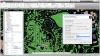
Topography in AutoCAD Featured
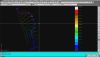
An add-on for AUTOCAD, for the triangulation of a set of POINTS, isolines, DWG drawing to Google Earth, the volume and center of gravity of a set of bodies or between surfaces composed of 3DFACE. You can load a file of points having the format: Number X Y Z Code. You can make cross sections, longitudinal profile and color-filled contour map.
Topography in IntelliCAD Featured
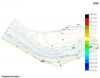
An add-on for IntelliCAD, for the triangulation of a set of POINTS, isolines, the volume and center of gravity of a set of bodies or between surfaces composed of 3DFACE. You can load a file of points having the format: Number X Y Z Code. You can make cross sections, longitudinal profile and color-filled contour map.
Note: Online eshop links lead to the online stores managed by the relevant producer.
CAD System
Category
