www.CADUTILS.com - more CAD for you!                     

GlobalCAD Architecture Featured

Expert software for architecture and land planning with 2D/3D design libraries, creative content, scheduling tools, and more.

GlobalCAD Architecture is the integrated architectural and land planning add-on solution for AutoCAD, AutoCAD Architecture and BricsCAD.

Utilize unique presentation tools for the creation of stunning hatch patterns and complex linetypes, generated quickly and easily from existing drawing objects.

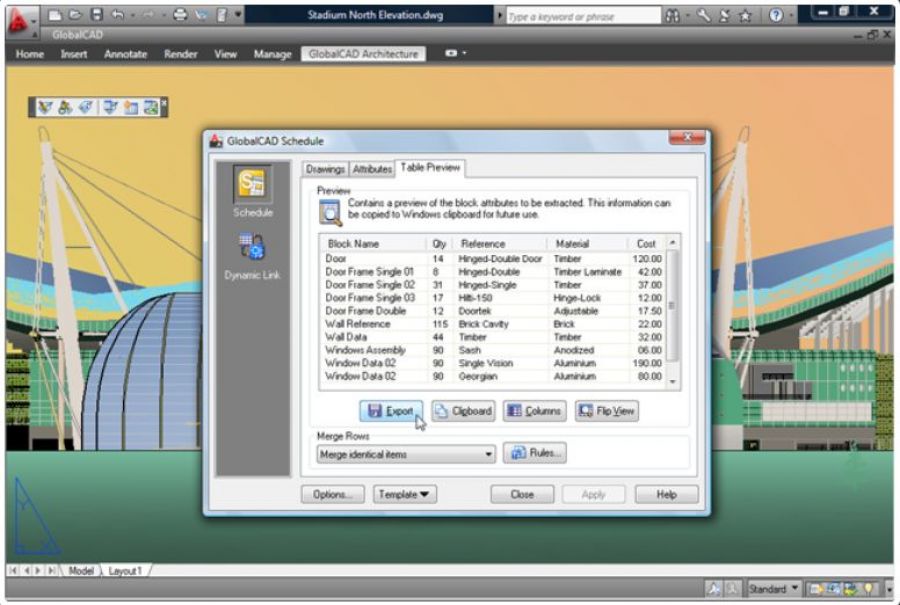
Create comprehensive schedules and bill of materials from block attribute data at the click of a button! Query drawings for quantities and export data to a variety of file formats including Microsoft Excel and Access.

Create accurate and intelligent site surveys and stunning 3D terrain models with a single mouse click! Using advanced algorithms, 3D models can be produced covering vast areas, both as polyface meshes or solids (including volumetric data).

Last modified on Friday, 04 March 2016 11:21

Additional Info

  • Features:


    Comprehensive Design Libraries

    • Freedom to investigate design concepts with professional 2D symbol libraries.
    • Published in association with industry experts, design libraries are indexed into familiar categories, saving valuable drafting time.
    • Instant ribbon/toolbar access to symbols, hatch patterns and complex linetypes.

    Render Ready 3D Models

    • Create stunning presentations with an outstanding array of 3D models, featuring architecture, landscape GIS and civil.
    • All models are render-ready with applied materials for fast, effortless photorealistic results directly within AutoCAD/BricsCAD.
    • Options also exist for seamless export to visualization packages such as Autodesk 3DS Max and AccuRender.

    Manage Details and Blocks

    • Browse and compare blocks and drawing details fast within libraries.
    • Create extensive libraries containing 2D, 3D and attributed blocks within seconds - with no user intervention necessary!

    Manage Survey Data

    • Generate surveys with ‘intelligent’ survey markers - for ultimate accuracy.
    • Convert almost any existing survey type such as 2D markers, blocks, points in 3D space, contour lines etc.
    • Move any markers in your drawing and their associative XYZ label automatically updates to reflect their new position!
    • Easily create 3D surface terrains (mesh and solids options) covering vast areas with a single mouse click.
    • Conversion tools to instantly transform any existing surface mesh to solids.

    Cost Estimates and Schedules

    • Quickly attach attribute and cost information to drawing objects and symbols.
    • Query drawings and export critical data to a variety of popular spreadsheet formats including MS Excel and Access.
    • Hot-link AutoCAD/BricsCAD drawings with Excel spreadsheets.
    • Modify the properties of blocks from within Excel for true design synchronization!
  • Publisher: GlobalCAD Consultants Ltd.
  • Operating Systems: -
  • CAD Requirements: AutoCAD 2000-2016, BricsCAD Pro/Platinum V11-V16
  • License types: Trial/Commercial
  • Price: $ 395

Note: Online eshop links lead to the online stores managed by the relevant producer.

Go to top