www.CADUTILS.com - more CAD for you!
Tags
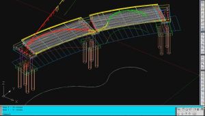
An add-on for AUTOCAD, which determines the developed (unfolded) section of one set of 3DSOLID, 3DMESH or 3DFACE entities and vertical plans passing through a 2D POLYLINE which may contain arcs, in XOY plane.
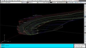
An add-on for AUTOCAD, which determines the 3D intersection curves between 2 sets consisting of 3DFACE, 3DSOLID or 3DMESH entities. The outcome is represented by 3DPOLY entities.
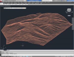
With CAD-Earth© you easily import/export images, objects and terrain meshes between Google Earth™ and major CAD programs
Now you can import georeferenced images and terrain meshes exactly as you see them in them in Google Earth. If you have placemarks, polygons, image overlays or routes in Google Earth they will appear in the image imported to your CAD application.
You will have the ability to create a terrain configuration mesh and get contour lines, profiles and sections.
The CAD-Earth Demo Version has a limit of 500 points when importing a terrain mesh from Google Earth™. Only 10 objects can be imported to or exported to Google Earth™. Also, all images imported to or exported to Google Earth™ have ‘CAD-Earth Demo Version’ text watermark lines. The CAD-Earth Registered Version can process any number of points and objects and the images don’t have text watermark lines.
Note: Online eshop links lead to the online stores managed by the relevant producer.
CAD System
Category
