www.CADUTILS.com - more CAD for you!
Tags
Expert software for architecture and land planning with 2D/3D design libraries, creative content, scheduling tools, and more.
GlobalCAD Architecture is the integrated architectural and land planning add-on solution for AutoCAD, AutoCAD Architecture and BricsCAD.
Utilize unique presentation tools for the creation of stunning hatch patterns and complex linetypes, generated quickly and easily from existing drawing objects.
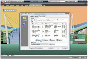
Create comprehensive schedules and bill of materials from block attribute data at the click of a button! Query drawings for quantities and export data to a variety of file formats including Microsoft Excel and Access.
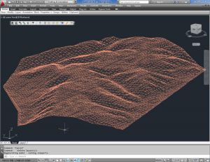
Create accurate and intelligent site surveys and stunning 3D terrain models with a single mouse click! Using advanced algorithms, 3D models can be produced covering vast areas, both as polyface meshes or solids (including volumetric data).
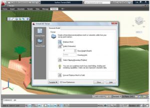
Easily create accurate and intelligent site surveys and stunning 3D terrain models in seconds!
The essential tools in GlobalCAD Terrain make it easy to create accurate and intelligent site surveys and stunning 3D terrain models with a single mouse click!.
Working with site survey data forms a critical component of any project. Information can be presented as anything from 2D markers to points in 3D space or contours. GlobalCAD Terrain gives you the tools to generate 'intelligent' surveys, either by converting an existing drawing or starting from scratch. Move any intelligent survey point marker and its associated XYZ value automatically updates to suit the new location!
Furthermore, you can generate 3D surface terrain models covering vast areas with a single mouse click. The terrain is developed by connecting the given survey points and forming triangles to create a surface model. Using advanced algorithms, GlobalCAD Terrain can produce these models as polyface meshes or solids (including volumetric data).
The software is avaiable for AutoCAD and BricsCAD as well.
An add-on for AUTOCAD, which determines the developed (unfolded) section of one set of 3DSOLID, 3DMESH or 3DFACE entities and vertical plans passing through a 2D POLYLINE which may contain arcs, in XOY plane.
An add-on for AUTOCAD, which determines the 3D intersection curves between 2 sets consisting of 3DFACE, 3DSOLID or 3DMESH entities. The outcome is represented by 3DPOLY entities.
InnerSoft CAD is a plug-in for AutoCAD that installs a set of productivity tools for Civil and Survey engineering, Counting, Estimating and measurements in construction project budgets. You can:
- Export to an Excel Sheet the values of Area/Length property or coordinates for various AutoCAD entities.
- Import from an Excel Sheet the vertex coordinates for a set of 2D polylines or 3D polylines (you can choose between 3 different methods). You can also import a set of points from Excel or a set of Texts with an insertion point for each one.
- Convert splines into polylines. Convert objects into polylines. Convert vertices of objects into points.
- Extract all block definitions of a drawing in individual AutoCAD files (each block definition in a single file).
- Sum the area or length property of a set of objects. Sum accumulated distance of a user defined walk in the drawing.
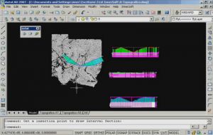
- Draw the longitudinal profile of a terrain or set of surfaces. Triangulate a set of points or mesh a model surface.
- Get measurements on AutoCAD drawings for construction project budgets.
- Create, open or save different libraries, which contain a series of AutoCAD drawings (*.dxf or *.dwg) organized by books.
- Draw a polyline graph, a 2D & 3D convex hull; lines, planes, circles and spheres by regression from a selection of points; clothoids, parabolas, catenaries, circular transition curves, Wholly Transitional Curves, clothoid transition curves and parabolic vertical transitions.
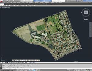
With CAD-Earth© you easily import/export images, objects and terrain meshes between Google Earth™ and major CAD programs
Now you can import georeferenced images and terrain meshes exactly as you see them in them in Google Earth. If you have placemarks, polygons, image overlays or routes in Google Earth they will appear in the image imported to your CAD application.
You will have the ability to create a terrain configuration mesh and get contour lines, profiles and sections.
The CAD-Earth Demo Version has a limit of 500 points when importing a terrain mesh from Google Earth™. Only 10 objects can be imported to or exported to Google Earth™. Also, all images imported to or exported to Google Earth™ have ‘CAD-Earth Demo Version’ text watermark lines. The CAD-Earth Registered Version can process any number of points and objects and the images don’t have text watermark lines.
With CAD-Earth© you easily import/export images, objects and terrain meshes between Google Earth™ and major CAD programs
Now you can import georeferenced images and terrain meshes exactly as you see them in them in Google Earth. If you have placemarks, polygons, image overlays or routes in Google Earth they will appear in the image imported to your CAD application.
You will have the ability to preview position of selected drawing entities in a map when selecting a coordinate system to georeference a drawing. Drawing entities can be moved, scaled or rotated in the map until they match the site.
The CAD-Earth Demo Version has a limit of 500 points when importing a terrain mesh from Google Earth™. Only 10 objects can be imported to or exported to Google Earth™. Also, all images imported to or exported to Google Earth™ have ‘CAD-Earth Demo Version’ text watermark lines. The CAD-Earth Registered Version can process any number of points and objects and the images don’t have text watermark lines.
Note: Online eshop links lead to the online stores managed by the relevant producer.
CAD System
Category
