www.CADUTILS.com - more CAD for you!
Tags
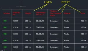
the tbl2cad is Microsoft Excel (2007, 2010, 2013 and 2016) add-in to export Excel tables to the DXF file format (as lines & text objects) as well as to import DXF tables containing the line & text objects to the Microsoft Excel table. The add-in is CAD independed and you can process your tables independent to your actual CAD system.
There is avaiable also free version. The free version of tbl2cad writes the text "Free version" instead of your text and it is designed especially to test the add-in with your Excel. Anyway - the free version can be also used to export the Excel table geometry (includuding the text sizes & position) to the DXF file.
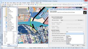
Spatial Manager™ for BricsCAD is a powerful BricsCAD plug-in designed for BricsCAD users who need to import, export and manage spatial data in a simple, fast and inexpensive way, which includes many possibilities not seen so far in BricsCAD. It comes in a lightweight application that runs inside BricsCAD and allows the user to import and export geospatial data between BricsCAD drawings and geospatial files, data servers or data stores.
It enables:
- Import into BricsCAD from Google Earth (KML or KMZ), OpenStreetMap (OSM or PBF), Shapefiles (SHP), Geography Markup Language (GML), GPS, Points (many formats), Excel, Access, ESRI ArcInfo, MapInfo, PostGIS, SQL Server, SQLite, and many more geospatial sources
- Export from BricsCAD to Google Earth (KML or KMZ), Shapefiles (SHP), Points (many formats), MapInfo, PostGIS, SQL Server, SQLite, and many more geospatial targets
- Transformation of coordinates optional
- Manage alphanumeric data tables as BricsCAD Extended Entity Data (EED). Viewer included
- Save Tasks to replay the import processes so many times as desired
Spatial Manager™ for BricsCAD Editions: Basic, Standard, Professional
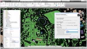
Spatial Manager™ for AutoCAD is a powerful AutoCAD plug-in designed for AutoCAD users who need to import, export and manage spatial data in a simple, fast and inexpensive way, which includes many possibilities not seen so far in AutoCAD. It comes in a lightweight application that runs inside AutoCAD and allows the user to import and export geospatial data between AutoCAD drawings and geospatial files, data servers or data stores.
It enables:
- Import into AutoCAD from Google Earth (KML or KMZ), OpenStreetMap (OSM or PBF), Shapefiles (SHP), Geography Markup Language (GML), GPS, Points (many formats), Excel, Access, ESRI ArcInfo, MapInfo, PostGIS, SQL Server, SQLite, and many more geospatial sources
- Export from AutoCAD to Google Earth (KML or KMZ), Shapefiles (SHP), Points (many formats), MapInfo, PostGIS, SQL Server, SQLite, and many more geospatial targets
- Transformation of coordinates optional
- Manage alphanumeric data tables as AutoCAD XDATA. Viewer included
- Save Tasks to replay the import processes so many times as desired
- Not only works in basic AutoCAD: also in AutoCAD Map 3D, AutoCAD Civil 3D, AutoCAD Architecture, etc.
Spatial Manager™ for AutoCAD Editions: Basic, Standard, Professional
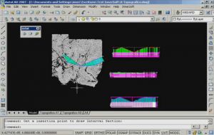
InnerSoft CAD is a plug-in for AutoCAD that installs a set of productivity tools for Civil and Survey engineering, Counting, Estimating and measurements in construction project budgets. You can:
- Export to an Excel Sheet the values of Area/Length property or coordinates for various AutoCAD entities.
- Import from an Excel Sheet the vertex coordinates for a set of 2D polylines or 3D polylines (you can choose between 3 different methods). You can also import a set of points from Excel or a set of Texts with an insertion point for each one.
- Convert splines into polylines. Convert objects into polylines. Convert vertices of objects into points.
- Extract all block definitions of a drawing in individual AutoCAD files (each block definition in a single file).
- Sum the area or length property of a set of objects. Sum accumulated distance of a user defined walk in the drawing.
- Draw the longitudinal profile of a terrain or set of surfaces. Triangulate a set of points or mesh a model surface.
- Get measurements on AutoCAD drawings for construction project budgets.
- Create, open or save different libraries, which contain a series of AutoCAD drawings (*.dxf or *.dwg) organized by books.
- Draw a polyline graph, a 2D & 3D convex hull; lines, planes, circles and spheres by regression from a selection of points; clothoids, parabolas, catenaries, circular transition curves, Wholly Transitional Curves, clothoid transition curves and parabolic vertical transitions.
Note: Online eshop links lead to the online stores managed by the relevant producer.
CAD System
Category
