www.CADUTILS.com - more CAD for you!
Tags
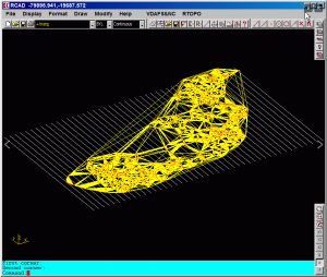
RTOPO - CAD for Topography, editing 3D points, triangulation, isolines, sections.
Together with RTOPO, is distributed the RCAD CAD system. It provides OpenGL real-time orbit, pan, zoom, shading, lighting and motion path animation. RCAD is similar with other popular CAD systems and can load and save DXF files. It has entries in the command text area, graphics area, menus and toolbars. It has commands for drawing and modification. RCAD can also run scripts and can be called from other programs.
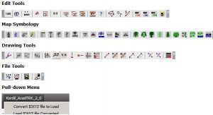
Kordil AcadTRK is a package that contains several LISP utilities useful for menu and mapping tools for AutoCAD above version 12.0. The package also contains CAD tools which supports for CAD programs supporting AutoLISP Languages (such as BrisCAD). The source codes of the utilities in the package are fully customizable and editable, and the package consisting of several programs are easily accessible through a pull-down and icon menus. Those who work on the construction or land surveying and also wish some useful enhancements for AutoCAD may give this package a try! The package works with AutoCAD version 12.0 and above. The package is equipped with an installation wizard and also with an installation instruction.
Kordil AcadTRK package is free of charge. However, it is expected to fill out the form before downloading.
InnerSoft CAD is a plug-in for AutoCAD that installs a set of productivity tools for Civil and Survey engineering, Counting, Estimating and measurements in construction project budgets. You can:
- Export to an Excel Sheet the values of Area/Length property or coordinates for various AutoCAD entities.
- Import from an Excel Sheet the vertex coordinates for a set of 2D polylines or 3D polylines (you can choose between 3 different methods). You can also import a set of points from Excel or a set of Texts with an insertion point for each one.
- Convert splines into polylines. Convert objects into polylines. Convert vertices of objects into points.
- Extract all block definitions of a drawing in individual AutoCAD files (each block definition in a single file).
- Sum the area or length property of a set of objects. Sum accumulated distance of a user defined walk in the drawing.
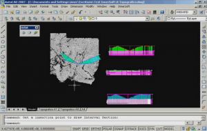
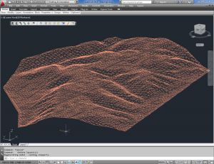
- Draw the longitudinal profile of a terrain or set of surfaces. Triangulate a set of points or mesh a model surface.
- Get measurements on AutoCAD drawings for construction project budgets.
- Create, open or save different libraries, which contain a series of AutoCAD drawings (*.dxf or *.dwg) organized by books.
- Draw a polyline graph, a 2D & 3D convex hull; lines, planes, circles and spheres by regression from a selection of points; clothoids, parabolas, catenaries, circular transition curves, Wholly Transitional Curves, clothoid transition curves and parabolic vertical transitions.
With CAD-Earth© you easily import/export images, objects and terrain meshes between Google Earth™ and major CAD programs
Now you can import georeferenced images and terrain meshes exactly as you see them in them in Google Earth. If you have placemarks, polygons, image overlays or routes in Google Earth they will appear in the image imported to your CAD application.
You will have the ability to create a terrain configuration mesh and get contour lines, profiles and sections.
The CAD-Earth Demo Version has a limit of 500 points when importing a terrain mesh from Google Earth™. Only 10 objects can be imported to or exported to Google Earth™. Also, all images imported to or exported to Google Earth™ have ‘CAD-Earth Demo Version’ text watermark lines. The CAD-Earth Registered Version can process any number of points and objects and the images don’t have text watermark lines.
Note: Online eshop links lead to the online stores managed by the relevant producer.
CAD System
Category
