www.CADUTILS.com - more CAD for you!
Tags
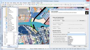
Spatial Manager™ for BricsCAD is a powerful BricsCAD plug-in designed for BricsCAD users who need to import, export and manage spatial data in a simple, fast and inexpensive way, which includes many possibilities not seen so far in BricsCAD. It comes in a lightweight application that runs inside BricsCAD and allows the user to import and export geospatial data between BricsCAD drawings and geospatial files, data servers or data stores.
It enables:
- Import into BricsCAD from Google Earth (KML or KMZ), OpenStreetMap (OSM or PBF), Shapefiles (SHP), Geography Markup Language (GML), GPS, Points (many formats), Excel, Access, ESRI ArcInfo, MapInfo, PostGIS, SQL Server, SQLite, and many more geospatial sources
- Export from BricsCAD to Google Earth (KML or KMZ), Shapefiles (SHP), Points (many formats), MapInfo, PostGIS, SQL Server, SQLite, and many more geospatial targets
- Transformation of coordinates optional
- Manage alphanumeric data tables as BricsCAD Extended Entity Data (EED). Viewer included
- Save Tasks to replay the import processes so many times as desired
Spatial Manager™ for BricsCAD Editions: Basic, Standard, Professional
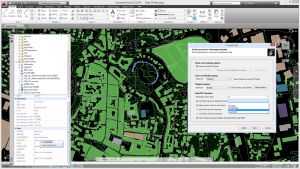
Spatial Manager™ for AutoCAD is a powerful AutoCAD plug-in designed for AutoCAD users who need to import, export and manage spatial data in a simple, fast and inexpensive way, which includes many possibilities not seen so far in AutoCAD. It comes in a lightweight application that runs inside AutoCAD and allows the user to import and export geospatial data between AutoCAD drawings and geospatial files, data servers or data stores.
It enables:
- Import into AutoCAD from Google Earth (KML or KMZ), OpenStreetMap (OSM or PBF), Shapefiles (SHP), Geography Markup Language (GML), GPS, Points (many formats), Excel, Access, ESRI ArcInfo, MapInfo, PostGIS, SQL Server, SQLite, and many more geospatial sources
- Export from AutoCAD to Google Earth (KML or KMZ), Shapefiles (SHP), Points (many formats), MapInfo, PostGIS, SQL Server, SQLite, and many more geospatial targets
- Transformation of coordinates optional
- Manage alphanumeric data tables as AutoCAD XDATA. Viewer included
- Save Tasks to replay the import processes so many times as desired
- Not only works in basic AutoCAD: also in AutoCAD Map 3D, AutoCAD Civil 3D, AutoCAD Architecture, etc.
Spatial Manager™ for AutoCAD Editions: Basic, Standard, Professional
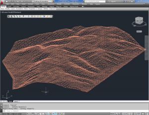
With CAD-Earth© you easily import/export images, objects and terrain meshes between Google Earth™ and major CAD programs
Now you can import georeferenced images and terrain meshes exactly as you see them in them in Google Earth. If you have placemarks, polygons, image overlays or routes in Google Earth they will appear in the image imported to your CAD application.
You will have the ability to create a terrain configuration mesh and get contour lines, profiles and sections.
The CAD-Earth Demo Version has a limit of 500 points when importing a terrain mesh from Google Earth™. Only 10 objects can be imported to or exported to Google Earth™. Also, all images imported to or exported to Google Earth™ have ‘CAD-Earth Demo Version’ text watermark lines. The CAD-Earth Registered Version can process any number of points and objects and the images don’t have text watermark lines.
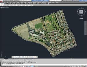
With CAD-Earth© you easily import/export images, objects and terrain meshes between Google Earth™ and major CAD programs
Now you can import georeferenced images and terrain meshes exactly as you see them in them in Google Earth. If you have placemarks, polygons, image overlays or routes in Google Earth they will appear in the image imported to your CAD application.
You will have the ability to preview position of selected drawing entities in a map when selecting a coordinate system to georeference a drawing. Drawing entities can be moved, scaled or rotated in the map until they match the site.
The CAD-Earth Demo Version has a limit of 500 points when importing a terrain mesh from Google Earth™. Only 10 objects can be imported to or exported to Google Earth™. Also, all images imported to or exported to Google Earth™ have ‘CAD-Earth Demo Version’ text watermark lines. The CAD-Earth Registered Version can process any number of points and objects and the images don’t have text watermark lines.
Note: Online eshop links lead to the online stores managed by the relevant producer.
CAD System
Category
