www.CADUTILS.com - more CAD for you!
Tags
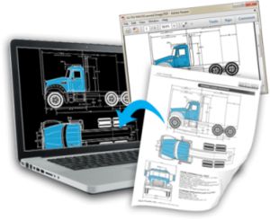
This converter is to convert PDF into DWG and DXF, as well as vector and raster into vectorized editable drawing, the version of AutoCAD 2016~R14 is supported.
Retain arcs: Using Smart Object Recognition technology, arc in PDF retain its accuracy and clearness.
Retain lines: It is a basic function, but others may not always keep its correctness of location, shape and thickness, we’ve been experienced dealing these problems.
Retain Texts: Need to convert solids and hatches from PDF to DWG, or just to keep border lines of those entities? AutoDWG PDF to DWG converter is the choice!
Raster to Vector: Having hand draw or scanned blueprint? No problem, this program is capable of vectorizing scanned raster images, and converting them to central lines or border lines.
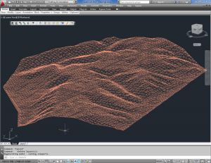
With CAD-Earth© you easily import/export images, objects and terrain meshes between Google Earth™ and major CAD programs
Now you can import georeferenced images and terrain meshes exactly as you see them in them in Google Earth. If you have placemarks, polygons, image overlays or routes in Google Earth they will appear in the image imported to your CAD application.
You will have the ability to create a terrain configuration mesh and get contour lines, profiles and sections.
The CAD-Earth Demo Version has a limit of 500 points when importing a terrain mesh from Google Earth™. Only 10 objects can be imported to or exported to Google Earth™. Also, all images imported to or exported to Google Earth™ have ‘CAD-Earth Demo Version’ text watermark lines. The CAD-Earth Registered Version can process any number of points and objects and the images don’t have text watermark lines.
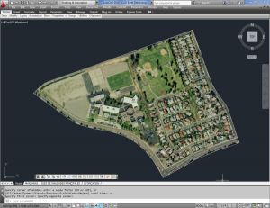
With CAD-Earth© you easily import/export images, objects and terrain meshes between Google Earth™ and major CAD programs
Now you can import georeferenced images and terrain meshes exactly as you see them in them in Google Earth. If you have placemarks, polygons, image overlays or routes in Google Earth they will appear in the image imported to your CAD application.
You will have the ability to preview position of selected drawing entities in a map when selecting a coordinate system to georeference a drawing. Drawing entities can be moved, scaled or rotated in the map until they match the site.
The CAD-Earth Demo Version has a limit of 500 points when importing a terrain mesh from Google Earth™. Only 10 objects can be imported to or exported to Google Earth™. Also, all images imported to or exported to Google Earth™ have ‘CAD-Earth Demo Version’ text watermark lines. The CAD-Earth Registered Version can process any number of points and objects and the images don’t have text watermark lines.
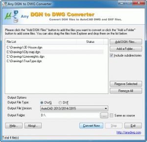
Any DGN to DWG Converter batch converts DGN files to AutoCAD DWG/DXF files.
With the free trial of the program, you may test it free of charge for 15-times. If you want to continue to use it after the trial period, please register the program. The registration fee for Any DGN to DWG Converter as low as US $289. The registration fee includes lifetime technical support and lifetime free future upgrades.
You can order the program over the Internet. The ordering page is on a secure server, ensuring that your confidential information remains confidential. After you submit your order, you will receive your Registration Code in an e-mail message, usually in about 5 to 30 minutes. The Registration Code you receive will work with the current release and all future versions.
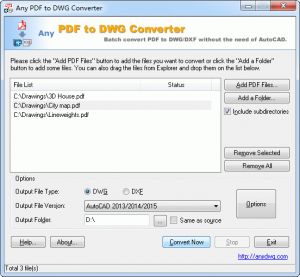
Any PDF to DWG Converter batch converts PDF to DWG and PDF to DXF format for fast and efficient editing in AutoCAD. It allows you to easy convert PDF to DWG and PDF to DXF without the need of AutoCAD.
With the free trial of the program, you may test it free of charge for 30-times. If you want to continue to use it after the trial period, you must register the program. The registration fee for Any PDF to DWG Converter as low as US $180. The registration fee includes lifetime technical support and lifetime free future upgrades.
You can order the program over the Internet. The ordering page is on a secure server, ensuring that your confidential information remains confidential. After you submit your order, you will receive your Registration Code in an e-mail message, usually in about 5 to 30 minutes. The Registration Code you receive will work with the current release and all future versions.
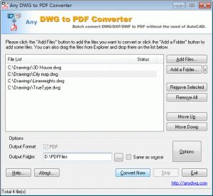
Any DWG to PDF Converter is a batch converter that allows you to convert DWG to PDF, DXF to PDF and DWF to PDF without the need of AutoCAD.
With the free trial of the program, you may test it free of charge for 30-times. If you want to continue to use it after the trial period, you must register the program. The registration fee for Any DWG to PDF Converter as low as US $83. The registration fee includes lifetime technical support and lifetime free future upgrades.
You can order the program over the Internet. The ordering page is on a secure server, ensuring that your confidential information remains confidential. After you submit your order, you will receive your Registration Code in an e-mail message, usually in about 5 to 30 minutes. The Registration Code you receive will work with the current release and all future versions.
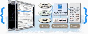
All-in-one DWG Converter - Batch DWG converter that allows you to convert DWG to PDF, WMF, JPEG, TIFF, EPS, SVG, CGM...,Supports command line parameters, it is also a very nice Free DWG Viewer.
With ACME CAD Converter you can convert DWG to DXF, DWG, DXF, DWF to PDF / DWG, DXF, DWF to EPS, CGM, HPGL(*.PLT) / DWG, DXF, DWF to WMF, BMP, GIF, JPEG, TIFF, PNG, TGA, PCX / DWG, DXF, DWF to SVG. It supports batch converts multi DWG DXF and DWF files to a single PDF / it Inserts DWG DXF and DWF into MS Word.(converts DWG to WMF) / replaces the missing fonts / Batch recovers DWG and DXF files / Packages multi-DWG or DXF drawings together into a zip file with all related resource files (such as: font, raster image, XRef files...) and it also includes Free DWG Viewer.
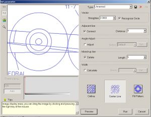
Acme TraceArt provides professional and fast transform functions from raster drawing into vector format; it can be used in various engineering drawings including architectural, mechanical, geological, GIS, electrical drawings etc.
TraceART is a professional raster to vector conversion program (Vectorizer). TraceART can let you quickly convert uneditable scanned paper drawings into accurate vector files for editing in any CAD program. It saves the converted file as an industry standard DXF file (Data Exchange Format) that can be read by any CAD program that supports this format. TraceART is a direct replacement for traditional tracing and digitizing, releases you from tiring work.
Note: Online eshop links lead to the online stores managed by the relevant producer.
CAD System
Category
