www.CADUTILS.com - more CAD for you!
Tags
CAD Converters (28)
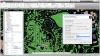
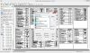
Spatial Manager™ for AutoCAD is a powerful AutoCAD plug-in designed for AutoCAD users who need to import, export and manage spatial data in a simple, fast and inexpensive way, which includes many possibilities not seen so far in AutoCAD. It comes in a lightweight application that runs inside AutoCAD and allows the user to import and export geospatial data between AutoCAD drawings and geospatial files, data servers or data stores.
It enables:
- Import into AutoCAD from Google Earth (KML or KMZ), OpenStreetMap (OSM or PBF), Shapefiles (SHP), Geography Markup Language (GML), GPS, Points (many formats), Excel, Access, ESRI ArcInfo, MapInfo, PostGIS, SQL Server, SQLite, and many more geospatial sources
- Export from AutoCAD to Google Earth (KML or KMZ), Shapefiles (SHP), Points (many formats), MapInfo, PostGIS, SQL Server, SQLite, and many more geospatial targets
- Transformation of coordinates optional
- Manage alphanumeric data tables as AutoCAD XDATA. Viewer included
- Save Tasks to replay the import processes so many times as desired
- Not only works in basic AutoCAD: also in AutoCAD Map 3D, AutoCAD Civil 3D, AutoCAD Architecture, etc.
Spatial Manager™ for AutoCAD Editions: Basic, Standard, Professional
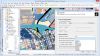
Spatial Manager™ for BricsCAD is a powerful BricsCAD plug-in designed for BricsCAD users who need to import, export and manage spatial data in a simple, fast and inexpensive way, which includes many possibilities not seen so far in BricsCAD. It comes in a lightweight application that runs inside BricsCAD and allows the user to import and export geospatial data between BricsCAD drawings and geospatial files, data servers or data stores.
It enables:
- Import into BricsCAD from Google Earth (KML or KMZ), OpenStreetMap (OSM or PBF), Shapefiles (SHP), Geography Markup Language (GML), GPS, Points (many formats), Excel, Access, ESRI ArcInfo, MapInfo, PostGIS, SQL Server, SQLite, and many more geospatial sources
- Export from BricsCAD to Google Earth (KML or KMZ), Shapefiles (SHP), Points (many formats), MapInfo, PostGIS, SQL Server, SQLite, and many more geospatial targets
- Transformation of coordinates optional
- Manage alphanumeric data tables as BricsCAD Extended Entity Data (EED). Viewer included
- Save Tasks to replay the import processes so many times as desired
Spatial Manager™ for BricsCAD Editions: Basic, Standard, Professional
The SPLOT program is a highly effective tool intended for simulating the HP-GL/2, HP-GL, HP-RTL, or DXY-GL plotters on the display of your PC. A partial support of the PCL language is also provided. The SPLOT program is the very thing you need to make your work with the plotter more effective. The SPLOT program will give you a guarantee you will always draw on your plotter what you really want. Moreover SPLOT program will allow you to convert plotter drawings to various other formats, so in many cases you will not need to draw them on plotter. That is why it will save your nerves, your time, your plotter, pens, ink and paper, that means your money.
It also exports a PLT file to the PDF, TIFF, PNG, JPEG, BMP, WMP, HPGL, HPGL/2, DXY-GL, DXF, DXB and metafile formats.
Tbl2cad Featured
the tbl2cad is Microsoft Excel (2007, 2010, 2013 and 2016) add-in to export Excel tables to the DXF file format (as lines & text objects) as well as to import DXF tables containing the line & text objects to the Microsoft Excel table. The add-in is CAD independed and you can process your tables independent to your actual CAD system.
There is avaiable also free version. The free version of tbl2cad writes the text "Free version" instead of your text and it is designed especially to test the add-in with your Excel. Anyway - the free version can be also used to export the Excel table geometry (includuding the text sizes & position) to the DXF file.

Tetra4D Converter is the world’s leading solution for converting native 3D CAD data into rich, interactive 3D PDF documents, including full support for precise solid geometry and Product Manufacturing.
With Tetra4D Converter you can accurately convert 3D data from the latest versions of CATIA, Pro/E, SOLIDWORKS, Inventor, Creo, I-deas, IGES, Parasolid, STEP, VRML, and all other major CAD applications
Export precise geometric 3D CAD data to STEP, IGES, JT, STL and Parasolid from all major CAD formats for use in downstream applications.
Tetra4D is Adobe’s exclusive provider of 3D PDF technology guaranteeing 100% compatibility to Adobe Reader and Adobe Acrobat
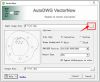
VectorNow Raster to Vector converter is a stand-alone program to convert scanned drawings, maps and images to vector files (DWG/DXF) to edit in CAD applications.
Support various source and target formats: VectorNow Raster to Vector converter is to convert raster images to vector images, supporting most popular formats, such as BMP, GIF, JPG, PNG TIF, etc for input format and DWG and DXF for output format.
Easy using and friendly settings: This converter is simple, quick and easy to use. There are only steps for the conversion and settings are friendly, usually you may use default settings.
Note: Online eshop links lead to the online stores managed by the relevant producer.
CAD System
Category
