www.CADUTILS.com - more CAD for you!
On this CAD website you find various CAD utilities for various CAD Systems.
The website has just started... there will be added more usefull CAD utilities during next weeks.
Tags
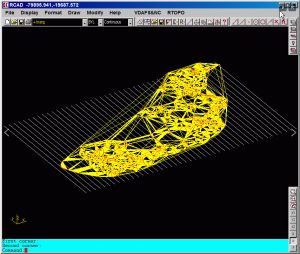
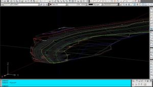
RTOPO - CAD for Topography, editing 3D points, triangulation, isolines, sections.
Together with RTOPO, is distributed the RCAD CAD system. It provides OpenGL real-time orbit, pan, zoom, shading, lighting and motion path animation. RCAD is similar with other popular CAD systems and can load and save DXF files. It has entries in the command text area, graphics area, menus and toolbars. It has commands for drawing and modification. RCAD can also run scripts and can be called from other programs.
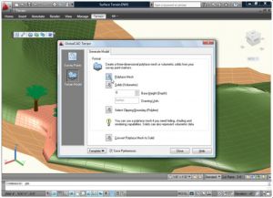
Easily create accurate and intelligent site surveys and stunning 3D terrain models in seconds!
The essential tools in GlobalCAD Terrain make it easy to create accurate and intelligent site surveys and stunning 3D terrain models with a single mouse click!.
Working with site survey data forms a critical component of any project. Information can be presented as anything from 2D markers to points in 3D space or contours. GlobalCAD Terrain gives you the tools to generate 'intelligent' surveys, either by converting an existing drawing or starting from scratch. Move any intelligent survey point marker and its associated XYZ value automatically updates to suit the new location!
Furthermore, you can generate 3D surface terrain models covering vast areas with a single mouse click. The terrain is developed by connecting the given survey points and forming triangles to create a surface model. Using advanced algorithms, GlobalCAD Terrain can produce these models as polyface meshes or solids (including volumetric data).
The software is avaiable for AutoCAD and BricsCAD as well.
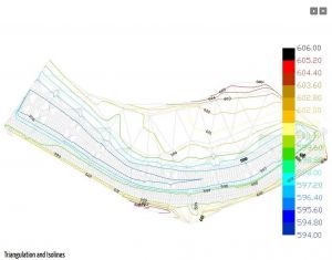
An add-on for IntelliCAD, for the triangulation of a set of POINTS, isolines, the volume and center of gravity of a set of bodies or between surfaces composed of 3DFACE. You can load a file of points having the format: Number X Y Z Code. You can make cross sections, longitudinal profile and color-filled contour map.
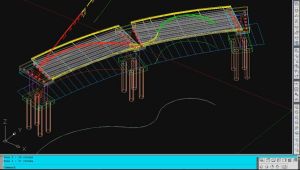
An add-on for AUTOCAD, which determines the developed (unfolded) section of one set of 3DSOLID, 3DMESH or 3DFACE entities and vertical plans passing through a 2D POLYLINE which may contain arcs, in XOY plane.
An add-on for AUTOCAD, which determines the 3D intersection curves between 2 sets consisting of 3DFACE, 3DSOLID or 3DMESH entities. The outcome is represented by 3DPOLY entities.
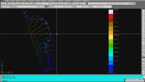
An add-on for AUTOCAD, for the triangulation of a set of POINTS, isolines, DWG drawing to Google Earth, the volume and center of gravity of a set of bodies or between surfaces composed of 3DFACE. You can load a file of points having the format: Number X Y Z Code. You can make cross sections, longitudinal profile and color-filled contour map.
Note: Online eshop links lead to the online stores managed by the relevant producer.
CAD System
Category
