www.CADUTILS.com - more CAD for you!
On this CAD website you find various CAD utilities for various CAD Systems.
The website has just started... there will be added more usefull CAD utilities during next weeks.
Tags
All CAD utilities (91)
AutoDWG PDF to DWG Pro Featured
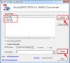
This converter is to convert PDF into DWG and DXF, as well as vector and raster into vectorized editable drawing, the version of AutoCAD 2016~R14 is supported.
Batch mode supported: convert hundreds of your files in one go.
Retain arcs: Using Smart Object Recognition technology, arc in PDF retain its accuracy and clearness.
Retain lines: It is a basic function, but others may not always keep its correctness of location, shape and thickness, we’ve been experienced dealing these problems.
Retain Texts: Need to convert solids and hatches from PDF to DWG, or just to keep border lines of those entities? AutoDWG PDF to DWG converter is the choice!
Raster to Vector: Having hand draw or scanned blueprint? No problem, this program is capable of vectorizing scanned raster images, and converting them to central lines or border lines.
AutoDWG PDF to DWG Stand-alone Featured
This converter is to convert PDF into DWG and DXF, as well as vector and raster into vectorized editable drawing, the version of AutoCAD 2016~R14 is supported.
Retain arcs: Using Smart Object Recognition technology, arc in PDF retain its accuracy and clearness.
Retain lines: It is a basic function, but others may not always keep its correctness of location, shape and thickness, we’ve been experienced dealing these problems.
Retain Texts: Need to convert solids and hatches from PDF to DWG, or just to keep border lines of those entities? AutoDWG PDF to DWG converter is the choice!
Raster to Vector: Having hand draw or scanned blueprint? No problem, this program is capable of vectorizing scanned raster images, and converting them to central lines or border lines.
This application offers quick and easy printing and converting of batches of MicroStation documents; an indispensable tool to every CAD manager and MicroStation user.
It can also convert batches of MicroStation documents to DWG, DXF, DGN V7 and DGN V8 file formats.
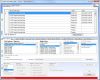
Batch Plot DWG is a comprehensive set of utilities designed to execute repetitive tasks quickly and easily. Plotting and converting batches of AutoCAD drawings are some of the most popular tasks included in the program.
It features several modes to select files to work with, notably: drag and drop, loading Excel lists, or searching for files in selected folders.
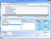
Batch Print SW is a comprehensive set of utilities designed to execute repetitive tasks quickly and easily. Printing and converting batches of SolidWorks documents are some of the most popular tasks included in the program (CATIA, DWG, DXF, eDrawings, IGES, JPG, PDF, PDF 3D, STEP, STL and TIF).
It features several modes to select files to work with, notably: drag and drop, loading Excel lists, or searching for files in selected folders.
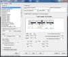
Free BricsCAD tool! for Vehicle Turning Simulation (Swept path analysis)
10 default types of vehicles are supported. Every vehicletype has its own figuration ruled by a combination of segments, the first segment is the truck, the second is either a trailer or a tow bar and so on. You can easily create your own vehicles by copying a existing vehicle and change parameters. You can use up to 4 segments including the truck, that would give you a Triple trailer and we think that would cover most of the common situations.
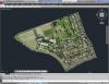
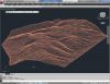
With CAD-Earth© you easily import/export images, objects and terrain meshes between Google Earth™ and major CAD programs
Now you can import georeferenced images and terrain meshes exactly as you see them in them in Google Earth. If you have placemarks, polygons, image overlays or routes in Google Earth they will appear in the image imported to your CAD application.
You will have the ability to preview position of selected drawing entities in a map when selecting a coordinate system to georeference a drawing. Drawing entities can be moved, scaled or rotated in the map until they match the site.
The CAD-Earth Demo Version has a limit of 500 points when importing a terrain mesh from Google Earth™. Only 10 objects can be imported to or exported to Google Earth™. Also, all images imported to or exported to Google Earth™ have ‘CAD-Earth Demo Version’ text watermark lines. The CAD-Earth Registered Version can process any number of points and objects and the images don’t have text watermark lines.
With CAD-Earth© you easily import/export images, objects and terrain meshes between Google Earth™ and major CAD programs
Now you can import georeferenced images and terrain meshes exactly as you see them in them in Google Earth. If you have placemarks, polygons, image overlays or routes in Google Earth they will appear in the image imported to your CAD application.
You will have the ability to create a terrain configuration mesh and get contour lines, profiles and sections.
The CAD-Earth Demo Version has a limit of 500 points when importing a terrain mesh from Google Earth™. Only 10 objects can be imported to or exported to Google Earth™. Also, all images imported to or exported to Google Earth™ have ‘CAD-Earth Demo Version’ text watermark lines. The CAD-Earth Registered Version can process any number of points and objects and the images don’t have text watermark lines.
Free AutoCAD and ZWCAD+ tool! Now with Vehicle Turning Simulation (Swept path analysis)
CadTools (ToolBox) is a software developed for Civil Engineers using AutoCAD or ZWCAD.
With CadTools you can create your own surface models based on objects in the drawing or import triangles from DWG (other civil software). You can create profiles and cross-sections of multiple surfaces, calculate volumes and plot contours.
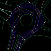
Vehicle turning software simulates vehicle turning at low speed and determines vehicle tire tracking and swept paths. Its useful in the design of road intersections, parking lots and other vehicular facilities.
10 default types of vehicles are supported. Every vehicletype has its own figuration ruled by a combination of segments, the first segment is the truck, the second is either a trailer or a tow bar and so on. You can easily create your own vehicles by copying a existing vehicle and change parameters. You can use up to 4 segments including the truck, that would give you a Triple trailer and we think that would cover most of the common situations.
Note: Online eshop links lead to the online stores managed by the relevant producer.
CAD System
Category
