www.CADUTILS.com - more CAD for you!
On this CAD website you find various CAD utilities for various CAD Systems.
The website has just started... there will be added more usefull CAD utilities during next weeks.
Tags
All CAD utilities (91)
Smart VectorImage : is a stand-alone program that converts scanned drawings, maps and raster images into accurate vector files (such as DXF, EPS, SVG) for editing in any CAD application.

SmartDWG DWG to PDF Converter is a batch converter that allows you to convert DWG to PDF, DXF to PDF and DWF to PDF without the need of AutoCAD.
The "Pro" version supports command line.
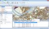
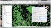
Spatial Manager Desktop™ is a desktop application designed to manage spatial data in a simple, fast and inexpensive way.
It enables: read and write spatial data using a wide range of file formats and spatial servers, Transform geometries between CRSs, Easily create and print maps, Use Tasks to automate any import and export process, Interface simple, intuitive and productive, Lightweight, easy and powerful
Spatial Manager Desktop™ will calculate geometric transformations of the features in line with the import or export processes, which will depend on the chosen Coordinate Reference System (CRS) for the source and target data.
Spatial Manager Desktop™ incorporates the UDS technology to easily connect with spatial database servers, or data stores, and also as the way the user can define the path to a particular spatial data file, including their own connection parameters.
Spatial Manager Desktop™ tasks are the way the user can save any import or export process and its parameters in order to run repetitive processes for import or export data tables.
Spatial Manager Desktop Editions: Basic, Standard, Professional
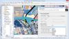
Spatial Manager™ for AutoCAD is a powerful AutoCAD plug-in designed for AutoCAD users who need to import, export and manage spatial data in a simple, fast and inexpensive way, which includes many possibilities not seen so far in AutoCAD. It comes in a lightweight application that runs inside AutoCAD and allows the user to import and export geospatial data between AutoCAD drawings and geospatial files, data servers or data stores.
It enables:
- Import into AutoCAD from Google Earth (KML or KMZ), OpenStreetMap (OSM or PBF), Shapefiles (SHP), Geography Markup Language (GML), GPS, Points (many formats), Excel, Access, ESRI ArcInfo, MapInfo, PostGIS, SQL Server, SQLite, and many more geospatial sources
- Export from AutoCAD to Google Earth (KML or KMZ), Shapefiles (SHP), Points (many formats), MapInfo, PostGIS, SQL Server, SQLite, and many more geospatial targets
- Transformation of coordinates optional
- Manage alphanumeric data tables as AutoCAD XDATA. Viewer included
- Save Tasks to replay the import processes so many times as desired
- Not only works in basic AutoCAD: also in AutoCAD Map 3D, AutoCAD Civil 3D, AutoCAD Architecture, etc.
Spatial Manager™ for AutoCAD Editions: Basic, Standard, Professional
Spatial Manager™ for BricsCAD is a powerful BricsCAD plug-in designed for BricsCAD users who need to import, export and manage spatial data in a simple, fast and inexpensive way, which includes many possibilities not seen so far in BricsCAD. It comes in a lightweight application that runs inside BricsCAD and allows the user to import and export geospatial data between BricsCAD drawings and geospatial files, data servers or data stores.
It enables:
- Import into BricsCAD from Google Earth (KML or KMZ), OpenStreetMap (OSM or PBF), Shapefiles (SHP), Geography Markup Language (GML), GPS, Points (many formats), Excel, Access, ESRI ArcInfo, MapInfo, PostGIS, SQL Server, SQLite, and many more geospatial sources
- Export from BricsCAD to Google Earth (KML or KMZ), Shapefiles (SHP), Points (many formats), MapInfo, PostGIS, SQL Server, SQLite, and many more geospatial targets
- Transformation of coordinates optional
- Manage alphanumeric data tables as BricsCAD Extended Entity Data (EED). Viewer included
- Save Tasks to replay the import processes so many times as desired
Spatial Manager™ for BricsCAD Editions: Basic, Standard, Professional
The SPLOT program is a highly effective tool intended for simulating the HP-GL/2, HP-GL, HP-RTL, or DXY-GL plotters on the display of your PC. A partial support of the PCL language is also provided. The SPLOT program is the very thing you need to make your work with the plotter more effective. The SPLOT program will give you a guarantee you will always draw on your plotter what you really want. Moreover SPLOT program will allow you to convert plotter drawings to various other formats, so in many cases you will not need to draw them on plotter. That is why it will save your nerves, your time, your plotter, pens, ink and paper, that means your money.
It also exports a PLT file to the PDF, TIFF, PNG, JPEG, BMP, WMP, HPGL, HPGL/2, DXY-GL, DXF, DXB and metafile formats.
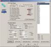
This module provides an easy way to create steel beams, tags, and beam schedule, using AutoCAD Architecture (ACA) or MEP, versions 2010 through 2014. Arched beam, sloped beams, and extensions are easily created. Hips and Valleys can be created using a special input dialog to handle the calculation involved. The beams created are actual ACA Structural Member objects, and standard ACA technology is used as the foundation for the tags and schedule as well, but with much enhancement.
This is great LISP utility - not just a library of profiles but a real application to use inside AutoCAD or others "like AutoCAD" systems. It has a graphical user interface with button selections to get what you need whether it is an end view, top or side view, or a 3D solid. All the dimensions are there including the small radii edges. Once you have made your selection you are given either a standard ACAD solid (not and ARX entity) or a simple 2D drawing. The end views are closed polylines which you can extrude, if needed.
Note: Online eshop links lead to the online stores managed by the relevant producer.
CAD System
Category
